|
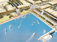
Alameda Point
Potential Commercial Mixed-Use Development

 Alameda
Point is the site of a potential major mixed-use project based on redevelopment of the
Alameda Naval Air Station. A Bay Trail extension is planned around
shoreline, connecting new parks. Alameda
Point is the site of a potential major mixed-use project based on redevelopment of the
Alameda Naval Air Station. A Bay Trail extension is planned around
shoreline, connecting new parks.
 back to waterfront access map
Status
SunCal Companies
was selected as master developer for the project in 2007. SunCal
proposed a plan that depended on voters approving Measure B, which would
have exempted the Point from Alameda restrictions on high-density
housing. In the wake of Alameda voters' rejection of Measure
B on February 4, 2010, the SunCal project's future was ended, and
relations between the developer and City broke down. See
press coverage.
In 2011, the City of Alameda began reviewing options
for the future of the former Naval Air Station property.
The City engaged the firm of Perkins + Will to work with
the community in a visioning and land-use planning process
for the Point. View
the scope of work and contract for this planning effort.
Following its adoption of the Waterfront
Town Center Plan for Alameda Point in July of 2014, the City
began leading the development process on a site-by-site
incrmental basis. On November 18, 2014, the City
entered into an exclusive negotiating agreement for
development of Site A, the first 68-acre parcel at the
Point.
More Information
 View Site A location.
 Download
the 2014 Waterfront Town
Center Plan.
  (Very large file! 50MB)
 View Waterfront Action's page on
the Alameda Point development
 View press coverage of Alameda
Point
 Visit Alameda Point Info, an
external web site covering the history and future of the site.
 Read
Over a Decade of Failure: Why Military Base Reuse at the Naval Air
Station, Alameda (Alameda Point) Has Been Unsuccessful, a Public
Policy Master's Thesis for California Polytechnic State University, San
Luis Obispo.
Location & Sky View
Internet Explorer users: Do
not click [+] to zoom in due to recent bug in Google
Maps.
Drag, zoom:[+][-], switch from Satellite to
Map or Earth view, explore...
Click the marker
for driving directions. marker
for driving directions.
View Larger Map
 back to waterfront access map
|