|
Shoreline Park, Bay Farm Island

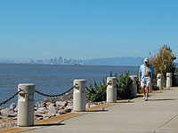 Shoreline
Park is a slender greenbelt that runs along the northern and western
perimeter of Bay Farm Island. Several developed mini-parks are
interspersed along the shore, and the Bay Trail runs through most of the
park's length. Shoreline
Park is a slender greenbelt that runs along the northern and western
perimeter of Bay Farm Island. Several developed mini-parks are
interspersed along the shore, and the Bay Trail runs through most of the
park's length.
 back to waterfront access map
More Information
 Visit our
detailed page on
Bay Farm Shoreline Park
for additional pictures and descriptions of park facilities.
Visit our
detailed page on
Bay Farm Shoreline Park
for additional pictures and descriptions of park facilities.
Status
 Complete
and open to the public. Complete
and open to the public.
Location & Sky View
Internet Explorer users: Do
not click [+] to zoom in due to recent bug in Google
Maps.
Drag, zoom:[+][-], switch from Satellite to
Map or Earth view, explore...
Click the marker
for driving directions. marker
for driving directions.
View Larger Map
back to waterfront access map
|