|
Chapter 3. Discovering Oakland's Waterfront
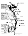
There are a great variety of land uses along
Oakland's nineteen miles of shoreline. For purposes of this study, the
shoreline is divided into three distinct areas, as shown on the map in
this chapter .
The western Waterfront (the Intermodal Gateway) is
dominated by the Port's marine terminals, the Oakland Army Base and
Naval Supply Depot. The southern Waterfront contains the Oakland
International Airport and subsidiary distribution and maintenance
facilities, traveler services and airport-oriented businesses (the
Airport Complex). The strip of land between the marine and air terminals
contains a wide variety of activities, including office, hotel and
retail developments, industrial firms, marinas and pockets of
undeveloped land (the Estuary Shore).
The Port of Oakland, created in 1928 to manage the
publicly-owned tideland in Oakland, controls the majority of the
Waterfront. It is one of the few Port authorities in the nation which
operates both airport and marine terminals. Although independent of the
City, there have been recent efforts to improve coordination between the
Port and City, especially in the areas of economic development and land
use planning.
The following describes the three areas of shoreline
and the distinct features of each area. Distinct issues related to each
area are included in this chapter in order to demonstrate the distinct
nature of the sectors of the Waterfront. Many of the issues are the
subject of other chapters of this booklet.
The lntermodal Gateway
The Harbor
The function of the Port's intermodal transportation
facilities is to transfer cargo between ships and either trucks or
railroads. The Port of Oakland was an early leader in development of
containerized cargo facilities, beginning in 1962. This year sixteen
million revenue tons of cargo will pass through Oakland's marine
terminals.
Oakland is one of three major intermodal gateways on
the West Coast. The others are Los Angeles/Long Beach and
Seattle/Tacoma. Over the past ten years, Oakland's market share has
declined to approximately fifteen percent. Long Beach and Tacoma now
handle 54% and 62% of cargo, respectively.
The Port is pursuing a major improvement program to
foster its competitive position among intermodal gateways. This includes
deepening the navigation channel, constructing new terminal facilities
and improving highway and rail connections.
Key Issues:
-
What are the Port's plans for marine terminal
expansion?
-
What is the relationship between the Port
improvements (including dredging) and the Port's competitive
position among West Coast ports ?
-
What is the economic impact of the Intermodal
Gateway, and how can Oakland increase the benefits it derives from
the facility's operation?
Military Bases
A substantial portion of the Intermodal Gateway is
devoted to two military installations. In 1936, the Department of
Defense began acquiring land, ultimately totaling more than five hundred
acres in the northern Waterfront for the Oakland Army Base and the Naval
Supply Depot. These installations occupy docks in the Middle Harbor
(Naval Supply Depot) and in the Outer Harbor adjacent to the Bay Bridge
(Oakland Army Base) and operate logistical centers on nearby land.
The level of activity at these bases has declined
substantially since their peak during the Korean War. The Port and the
Navy are presently negotiating the transfer of portions of the Naval
Supply Depot to the Port for expansion of its intermodal facilities.
Currently the fate of the Naval Supply Depot is in question with its
inclusion on the 1993 base closure list published by the Department of
Defense. The Port of Oakland has suggested that if closure were to
occur, the Depot could be quickly converted to productive use as an
expansion of the maritime terminals and as the location of the marine
terminals and as the location of distribution and trading facilities.
The Oakland Army Base, while not imminently
threatened, might be considered for closure as military reductions
continue. This land is ideally suited for distribution facilities, in
that it is adjacent to the proposed Cypress Freeway replacement. It also
is well suited to other uses given its location relative to West Oakland
industrial and residential development.
Key Issues:
-
What activities are presently conducted at these
two installations?
-
What is the economic impact of these facilities
within Oakland and in the Region?
-
What types of uses might be placed on these
sites if converted to civilian use?
Cypress Replacement
The Intermoda1 Gateway will be greatly affected by
the relocation of the Cypress Section of Highway 880 by more than a mile
closer to the shoreline. The proposed replacement structure will improve
truck access to the marine terminals and West Oakland industrial areas.
It will also offer new vistas of the bay and Waterfront.
Key Issues:
The Estuary Shore
 The Estuary Shore is a narrow strip of land between
Jack London Square and the Coliseum. It contains a wide variety of land
uses, including retail establishments and office buildings (e.g.
Embarcadero Cove; KTVU); boat repair and water-oriented small businesses
(many visible from Highway 880); residential developments (e.g.
Portabello, Executive Inn and residential neighborhoods in the High
Street area) and a Motley array of industrial uses unrelated to the
waterfront. A major marine terminal is located at the foot of Ninth
Avenue. The undeveloped site across Highway 880 from the Coliseum has
recently been considered for major retail development. The Estuary Shore is a narrow strip of land between
Jack London Square and the Coliseum. It contains a wide variety of land
uses, including retail establishments and office buildings (e.g.
Embarcadero Cove; KTVU); boat repair and water-oriented small businesses
(many visible from Highway 880); residential developments (e.g.
Portabello, Executive Inn and residential neighborhoods in the High
Street area) and a Motley array of industrial uses unrelated to the
waterfront. A major marine terminal is located at the foot of Ninth
Avenue. The undeveloped site across Highway 880 from the Coliseum has
recently been considered for major retail development.
Jack London Square and the Produce Market
Jack London Square contains the most highly
developed commercial activity on the Waterfront. This is the area of the
Waterfront which has the strongest relationship with downtown Oakland
and convention facilities.
The controversial expansion of Jack London Square
has been costly to the Port of Oakland, and has caused the Port to
become wary of further commercial ventures. Jack London Square's future
success may be bolstered by improved ferry service and the relocation of
Oakland's Amtrak terminal to Embarcadero Street.
Oakland's Produce Market is located south of
Broadway near Jack London Square. It is a lively wholesale marketplace
which houses many small businesses. However, its future is clouded by a
recent change in its ownership, increasing street congestion, and
skyrocketing land values.
Key Issues:
-
What is the future of Oakland's Produce Market?
-
What progress is being made toward filling
vacant retail space in Jack London Square and Jack London Village?
-
What plans are being considered for relocating
Oakland's Amtrak Station to the Jack London Square area?
-
What role does Jack London Square play in
downtown revitalization and Oakland's economic development strategy?
Estuary Park to Coliseum Shore
Jurisdiction of this area is haphazardly split
between the City of Oakland and the Port, complicating land use planning
and economic development. Therefore, cooperation between the City and
the Port is critical to the future of this area.
In addition, this area is isolated from the portion
of the city inland from Highway 880. In order to take advantage of the
great potential of this area, better connections are needed to link the
shoreline with inland Oakland and internally along the shoreline. A
major goal should be completion of a continuous pathway from Lake
Merritt along Lake Merritt Channel to Estuary Park.
Key Issues:
-
What are the Port's plans for commercial
development of vacant sites, such as adjacent to Jack London
Village. in Embarcadero Cove and along Highway 880?
-
How does the "Tidelands Trust" affect
utilization of Port land for housing and commercial activity?
-
What is the relationship between the City of
Oakland and the Port in planning land uses and economic development
programs in the Waterfront?
-
What are the City's and Port's plans for
enhancing public access and recreational uses of The Waterfront?
The Airport Complex
The Airport Complex consists of nearly three
thousand acres, containing the Oakland International Airport, the land
to the north of Hegenberger Road and west of Highway 880.
The Oakland International Airport was originally
established at North Field, which now serves as a civil aviation
facility. Having been inaugurated by Charles Lindbergh shortly after his
trans-Atlantic flight, it was the site of some of the most important
moments in early aviation history. It launched the first
circumnavigation of the world (Charles Kingsford-Smith - 1930) and
Amelia Earhart's trans-Pacific flight in 1937. This was the original hub
of commercial transcontinental airline travel, but when that era ended,
the airport was appropriated for military use in '1943.
Last year the Oakland International Airport served
more than 5.5 million passengers, making it the fastest growing airport
in the nation. It also handled nearly 500 million pounds of air cargo in
1991.
Airport operations account for significant amounts
of "spin-off" employment. Closely related industries such as the air
parcel distribution and aircraft maintenance provide more than five
thousand jobs. Additional spin-off jobs are in the hotels, restaurants
and car rental agencies which are dependent on the Airport. The Port
also operates the Airport Business Park.
Because of the Airport Complex's potential for
creating spin-off employment, there have been recent efforts to find
ways of creating training opportunities for Oakland residents in
occupations utilized by the Airport Complex. For example, the Port and
United Airlines have been working with the Oakland Unified School
District toward establishment of an "academy" in a local high school to
attract students into aviation-related industries. Other efforts, such
as the proposed creation of a Coliseum redevelopment area, are also
intended to tap this area's economic potential.
Key Issues:
-
What are plans for expansion of the Oakland
International Airport, and how do these plans affect the regional
role of the airport in the transportation of passengers and cargo?
-
What "spin-off" employment is caused by the
Airport Complex, and how can Oakland benefit from this potential?
< Previous Chapter |
Table of Contents | Next
Chapter >
|