Estuary Transformed

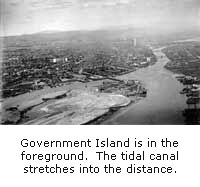 The
Oakland Estuary has been transformed to serve the needs of the cities at
its shore. A channel, 5 feet deep at extreme low tide, was cut through
the sand bar at its mouth in 1859. In 1877, the ship channel was
deepened to 20 feet at high tide; by 1939 it had reached 35 feet at low
tide; current dredging projects will deepen the channel to 42 feet. In
1901, the Army Corps of Engineers cut through the neck of land that
connected Oakland and Alameda. Alameda became an island, separated from
Oakland by the Tidal Canal. It is called the Tidal Canal because it was
supposed create a tidal flow that would scour out the Estuary ship
channel and minimize the continual need to dredge. However, the scouring
action of the tides has never been effective in keeping the ship channel
clear.
The
Oakland Estuary has been transformed to serve the needs of the cities at
its shore. A channel, 5 feet deep at extreme low tide, was cut through
the sand bar at its mouth in 1859. In 1877, the ship channel was
deepened to 20 feet at high tide; by 1939 it had reached 35 feet at low
tide; current dredging projects will deepen the channel to 42 feet. In
1901, the Army Corps of Engineers cut through the neck of land that
connected Oakland and Alameda. Alameda became an island, separated from
Oakland by the Tidal Canal. It is called the Tidal Canal because it was
supposed create a tidal flow that would scour out the Estuary ship
channel and minimize the continual need to dredge. However, the scouring
action of the tides has never been effective in keeping the ship channel
clear.
Deborah Cooper
Oakland Museum of California
 "Walk Along the Water"
© Oakland Museum of California, used with permission.
 Explore this Topic:
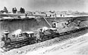 Image
of tidal canal excavation - Oakland History Room, Oakland Public
Library
Image
of tidal canal excavation - Oakland History Room, Oakland Public
Library
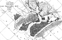 1856
Map of estuary and landforms - United States Coast Guard
1856
Map of estuary and landforms - United States Coast Guard
Google Maps current satellite image of estuary
 back to history map