San Leandro Creek and Its
Watershed

 Born
of a volcano, San Leandro Creek has its headwaters at the base of Sibley
Volcanic Regional Preserve. It gathers water funneled through steep
canyons and ancient remnants of redwood forests. Until the late 19th
century, the creek continued its seasonal flow to the lowlands, becoming
lost among the meandering sloughs and channels of the tidal and
freshwater wetlands.
Born
of a volcano, San Leandro Creek has its headwaters at the base of Sibley
Volcanic Regional Preserve. It gathers water funneled through steep
canyons and ancient remnants of redwood forests. Until the late 19th
century, the creek continued its seasonal flow to the lowlands, becoming
lost among the meandering sloughs and channels of the tidal and
freshwater wetlands.
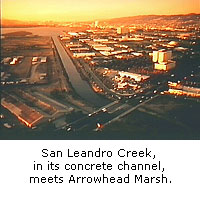
Today, although the creek travels a similar path, the surroundings and
stopovers are much different. The creek first encounters dams, like the
one at Lake Chabot, which provide emergency drinking water to the East
Bay. The creek then pauses in riffling pools in the heart of the city of
San Leandro and then passes on through concrete channels to meet the
Estuary at Arrowhead Marsh in the Martin Luther King, Jr. Regional
Shoreline.
San Leandro is one of the last remaining creeks to flow above ground its
entire length.
Sharol Nelson-Embry
East Bay Regional Park District
 "Walk Along the Water"
© Oakland Museum of California, used with permission.
 Explore this
Topic:
Explore this
Topic:
San
Leandro Creek watershed map - Oakland Museum of California
 back to history map